

Planning a manila to baguio no expressway route is not just about choosing roads that avoid tollways. It is about respecting distance, heat, fatigue, rain, fog, slow trucks, and the final mountain climb into Baguio. For cyclists and sub-400cc motorcycle riders, the ride can feel rewarding, but it should never be treated like a one-shot endurance dare.
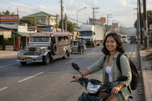
From Metro Manila, the lowland stretches can be hot, busy, and mentally tiring. Heat rises from the pavement, jeepneys and tricycles share the same lanes, and long gaps between comfortable stops can make a rider feel drained before the mountains even begin.
The real goal is not to arrive with a dramatic story. The goal is to arrive in Baguio safely enough to enjoy the cool air, warm food, and a proper night of rest.
At-a-Glance for Riders
The most practical travel window for a manila to baguio no expressway route is usually a very early Manila departure, with the mountain climb timed for daylight and clearer visibility. For sub-400cc motorcycles, expect a long full-day ride at minimum. For cyclists, this is often better planned as a multi-day effort with overnight stops.
Budget depends on your pace and comfort level, but set aside money for meals, water, fuel, emergency repairs, and a possible overnight before the climb. Crowd and traffic risk rises on weekends, holidays, long weekends, and during rainy afternoons.
Your rain or heat backup is simple: pause early, hydrate, wait out dangerous weather, or sleep before pushing into the mountains.
Reality Check: Avoid comparing your pace with riders on bigger bikes using expressways. No-expressway travel asks for more patience, more stops, and a more conservative safety margin.
What a Manila to Baguio No Expressway Route Means
A manila to baguio no expressway route means using regular national, provincial, and city roads instead of expressways such as NLEX, SCTEX, or TPLEX. For many sub-400cc motorcycle riders, this is not just a preference but a route-planning requirement because motorcycle access depends on expressway classification rules. For official context, riders can review the Toll Regulatory Board vehicle classification information before planning any expressway-related route.
Why sub-400cc motorcycles need a different plan
Small motorcycles often move through the same busy corridors used by trucks, buses, jeepneys, tricycles, private cars, and local commuters. Without expressways, travel time stretches because you pass town centers, intersections, school zones, markets, roadworks, and slow-moving traffic. A trip that looks direct on a map can feel much longer on the body.
Reality Check: Your motorcycle may be capable of long-distance travel, but your brakes, tires, lights, posture, luggage setup, and alertness matter more than confidence alone.
Why cyclists should plan around exposure, heat, trucks, and fatigue
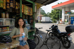
Cycling to Baguio demands even more planning. The lowlands of Bulacan, Pampanga, Tarlac, Pangasinan, and La Union can be punishing when the sun is high. There may be sari-sari stores and roadside eateries, but shade is not always where you need it.
Trucks can pass close, crosswinds can surprise you, and fatigue can blur judgment before the climb begins.
For cyclists, the manila to baguio no expressway route should be broken into realistic segments. It is better to arrive at the base of the climb with steady legs, topped-up water, and enough daylight than to force a late ascent while tired.
Quick Route Summary Before You Choose
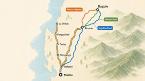 There are several no-expressway ways to reach Baguio, but three route corridors are the most useful to understand. Think of them as planning frameworks, not rigid turn-by-turn instructions. Road conditions, closures, weather, and local traffic can change, so riders should confirm the route before departure.
Best for simplicity: MacArthur Highway and Manila North Road corridor
The simplest manila to baguio no expressway route generally follows the familiar northbound corridor through Bulacan, Pampanga, Tarlac, Pangasinan, Rosario in La Union, then up toward Baguio via Marcos Highway, also known as Aspiras-Palispis Highway. This is the easiest to explain because it follows major towns and common northbound movement.
Reality Check: Simple does not mean easy. This corridor can be busy, hot, and slow, especially when you pass through commercial areas and town centers.
Best as an alternate: Bulacan, Nueva Ecija, Pangasinan corridor
The Bulacan, Nueva Ecija, Pangasinan option may suit riders who want an alternate inland movement or need to avoid congestion or disruptions along the more common MacArthur Highway and Manila North Road pattern. It can be useful, but navigation may require more attention, especially for riders unfamiliar with the towns.
Reality Check: An alternate corridor can reduce one kind of stress while adding another, such as extra distance, more turns, or fewer familiar stop points.
Best when conditions require a wider detour: La Union and Naguilian Road corridor
A longer option is to continue toward La Union and approach Baguio via Naguilian Road. This can make sense when riders are already coming from the La Union side, when the usual climb options are affected by closures, or when weather and traffic make another approach more practical.
Reality Check: Naguilian Road is not a shortcut from Manila for most riders. It is a wider detour that may become useful when safety, closures, or traffic conditions justify the added distance.
Corridor 1: Manila, Bulacan, Pampanga, Tarlac, Pangasinan, Rosario, then Marcos Highway
 For many riders, this is the default manila to baguio no expressway route because it follows recognizable highways and towns. The broad idea is to leave Manila, move north through Bulacan, continue through Pampanga and Tarlac, enter Pangasinan, reach the Rosario area in La Union, then climb toward Baguio through Marcos Highway or Aspiras-Palispis Highway.
Major towns and highways only
Use major corridors such as MacArthur Highway, Manila North Road, and connecting national roads, depending on your exact starting point in Manila. Riders should focus on town-to-town planning: Manila to Bulacan, Bulacan to Pampanga, Pampanga to Tarlac, Tarlac to Pangasinan, Pangasinan to Rosario, then Rosario to Baguio.
For cyclists, this town-based structure makes rest planning easier. For motorcycle riders, it helps with fuel planning, meal breaks, and mechanical checks. Instead of thinking only about the finish line, think about the next safe stop.
Why this is the easiest corridor to explain and follow
This corridor works well because it follows the natural northbound spine of Central Luzon. Services are generally easier to find: gas stations, vulcanizing shops, convenience stores, eateries, pharmacies, and basic lodging. A tired rider can usually find a place to pause before the situation becomes urgent.
Reality Check: The comfort of available services does not erase the tiring parts. You will still pass urban traffic, rough patches, intersections, and slow vehicles.
What makes it tiring without expressways
Without expressways, the road asks for constant attention. Riders deal with pedestrians, dogs, parked vehicles, public utility vehicles stopping suddenly, delivery trucks, and heat trapped in busy town roads.
On a sub-400cc motorcycle, the rhythm is stop-and-go. On a bicycle, the exposure is more physical: sun, dust, noise, and the repeated effort of accelerating again after interruptions.
This is why the manila to baguio no expressway route is less about speed and more about energy management. Eat before you feel weak. Drink before you are thirsty. Stop before your hands, back, or eyes begin asking for mercy.
Corridor 2: Manila, Bulacan, Nueva Ecija, Pangasinan, then Baguio
The Nueva Ecija corridor is a useful alternate when riders want to avoid some of the more congested or familiar sections of the classic northbound route. It can connect Manila and Bulacan toward Nueva Ecija, then onward to Pangasinan before eventually aiming for Baguio.
Who this route may suit
This option may suit riders who already know Central Luzon’s inland roads, cyclists who are breaking the journey into several days, or motorcycle riders who prefer a different flow from the usual MacArthur Highway and Manila North Road movement. It may also be considered when traffic advisories or roadworks make the default corridor less appealing.
Reality Check: Familiarity matters. A route that feels calm to a local rider can feel confusing to someone reading signs while tired, hot, or riding in low light.
Trade-offs in distance, heat, services, and navigation
The trade-off is that an alternate corridor can add complexity. You may encounter long warm stretches, less predictable stop spacing, or more navigation decisions. For cyclists, this means being disciplined with water and food.
For small-motorcycle riders, it means topping up fuel before long stretches and not assuming every town will have the exact service you need.
As with any manila to baguio no expressway route, do not rely only on one app line. Save an offline map, note the major towns, and have a simple paper or screenshot backup. When signal drops or the phone overheats, your plan should still make sense.
Corridor 3: Manila, Central Luzon, Pangasinan, La Union, then Naguilian Road
The La Union and Naguilian Road option is the longer, wider approach. Instead of treating Rosario and Marcos Highway as the obvious final movement, this corridor gives riders another mountain entry via Naguilian Road. It is especially worth understanding because Baguio-bound traffic, rain, closures, and road advisories can affect the best final climb.
When this longer option makes sense
This option makes sense when you are already close to La Union, when you have planned an overnight on that side, or when official advisories make another route more practical. For cyclists, it may work as part of a slower multi-day itinerary. For motorcycle riders, it can be a useful plan B when the usual approach feels too crowded or uncertain.
Reality Check: Longer routes can feel peaceful on paper but exhausting on the road. Choose this corridor because it improves safety or logistics, not because it sounds more adventurous.
Why it can be useful during closures, rain, or heavy Baguio-bound traffic
When mountain roads are affected by weather, landslides, repairs, crashes, or holiday traffic, having another approach in mind can reduce panic. Naguilian Road may become the safer available option depending on where you are and what advisories say. Always check official updates and your accommodation’s local advice before committing to the climb.
For Baguio arrival requirements, lodging information, and advisories, riders can review Baguio Visita before finalizing the trip.
Choosing the Final Climb to Baguio
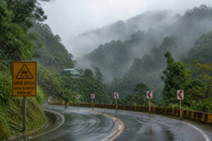 The final climb is where the ride changes character. The heat of the lowlands gives way to cooler air, but the road also becomes more technical. Expect curves, grade changes, fog, wet pavement, slow trucks, and sudden weather shifts.
This is not the part of the journey to rush.
Marcos Highway or Aspiras-Palispis Highway for the most practical default
For most riders planning a manila to baguio no expressway route, Marcos Highway or Aspiras-Palispis Highway is the most practical default final climb. It is generally wider than Kennon Road and easier to recommend for mixed traffic, especially for riders who want a more forgiving approach.
Reality Check: Wider does not mean risk-free. Rain, fog, buses, trucks, and impatient drivers can still make the climb stressful, so keep your pace conservative.
Kennon Road only if open, allowed, and conditions are dry and safe
Kennon Road is famous, scenic, and historically associated with Baguio, but it should not be treated as the automatic choice. Use Kennon only if it is open, allowed for your vehicle type and direction, and conditions are dry and safe. Road restrictions can change, especially after rain or maintenance work.
For cyclists and small motorcycles, narrow sections, curves, and limited escape space can make Kennon demanding. A beautiful road is not always the safest road for a tired rider near the end of a long trip.
Naguilian Road when approaching from La Union or when it is the safer available option
Naguilian Road is most logical when you are coming from the La Union side or when conditions point you away from other climbs. It can feel like a better fit for certain weather or traffic situations, but it still requires careful pacing, visibility, and attention to road surface.
Reality Check: The safest final climb is not always the shortest. Choose based on daylight, weather, advisories, your energy level, and your actual location.
Timing the Ride: Heat, Rain, Fog, and Safe Arrival Windows
Timing can make or break the manila to baguio no expressway route. A very early departure from Manila helps riders clear some city and lowland traffic before the day becomes too hot. It also creates a buffer for longer stops, small repairs, wrong turns, and weather pauses.
Best departure logic for riders leaving Manila
For motorcycle riders, leaving before sunrise can help, but only if your lights are strong, your route out of Manila is familiar, and you are fully awake. For cyclists, early departure also helps reduce heat exposure, but visibility gear is non-negotiable. Reflectors, rear lights, bright clothing, and disciplined lane positioning matter from the first kilometer.
Reality Check: Leaving early while sleep-deprived is not safer. Rest the night before, pack before bedtime, and do not start the ride already tired.
Why late afternoon mountain riding can be risky
Late afternoon is a risky time to begin the climb because fatigue, rain, fog, and fading light can overlap. Mountain weather can shift quickly. Wet pavement reflects headlights, fog hides curves, and slow trucks can create pressure from vehicles behind you.
For a conservative plan, aim to reach the base of the climb with enough daylight, enough energy, and enough patience to stop if conditions worsen. The relief of Baguio’s cooler air is sweeter when you are not arriving shaken.
What to do during rainy season or foggy conditions
During rainy season, treat every dark cloud seriously. Put on rain gear before you are soaked, protect your phone and documents, slow down before curves, and increase following distance. In fog, use lights, avoid sudden lane changes, and resist the urge to follow fast local vehicles too closely.
When weather becomes uncomfortable, stop somewhere safe and visible. A simple roadside eatery, sari-sari store, gas station, or covered waiting area can be the difference between a manageable delay and a dangerous climb.
Stop Planning for Fuel, Food, Hydration, and Fatigue
 A good manila to baguio no expressway route is built around stops, not just roads. Plan where to rest before you need it. Your body and your bike both perform better when you avoid desperation decisions.
Stop before you are desperate
Do not wait until your tank is nearly empty, your bottles are dry, or your hands are trembling. Small stops are part of the route. Buy water from sari-sari stores, eat something salty and familiar, stretch your back, check your tires, and let your eyes rest from the road.
Reality Check: Long rides often become unsafe because of small ignored discomforts. Numb hands, dry mouth, stiff shoulders, or a foggy mind are warnings, not background noise.
Fuel and water rules for small motorcycles and bicycles
For sub-400cc motorcycles, fuel up earlier than you think you need to, especially before less familiar stretches and before the climb. Check tire pressure, chain condition, brakes, lights, and luggage straps during fuel stops. A loose bag or weak brake feel should be handled before the mountains.
For bicycles, carry more water than your optimistic estimate. Bring electrolytes or oral rehydration salts, easy snacks, a repair kit, spare tubes, pump, lights, and cash. Not every small store accepts digital payments, and not every town will have the bike part you need.
When to end the day early
End the day early when fatigue changes your decision-making. Warning signs include repeated missed turns, sloppy braking, irritability, chills after rain, tunnel vision, or the feeling that you just want the ride to be over. That is the moment to find lodging, not the moment to prove something.
This is especially important for cyclists. Overnighting before the climb can turn a punishing ride into a safer, more memorable journey.
Safety Rules for Cyclists and Sub-400cc Motorcycle Riders
Every rider planning the manila to baguio no expressway route should think like a safety planner, not just a traveler. For wider road-safety habits, fatigue planning, and weather-aware travel, keep a practical guide like the Philippines travel safety guide in your pre-trip reading.
Visibility, lights, reflectors, rain gear, and brakes
Visibility is your first layer of protection. Use working headlights and taillights, reflective accents, and bright gear. Cyclists should use front and rear lights even in daytime if conditions are dim. Motorcycle riders should check brake feel, tire condition, mirrors, and horn before leaving Manila.
Reality Check: Rain gear is not only about comfort. Staying dry helps preserve body temperature, focus, and braking control during long wet stretches.
Group riding discipline and spacing
If riding in a group, agree on spacing, stop points, and regroup rules before departure. Do not pressure the slowest rider. Do not overtake blindly just to keep up. On climbs, give each rider enough room to react to potholes, trucks, wet patches, or sudden braking.
For cyclists, single-file riding may be safer on narrow sections. For motorcycle groups, staggered formation can help on open roads, but mountain curves require more space and individual judgment.
No shame in overnighting before the climb
There is no shame in ending the day in Pangasinan, Rosario, La Union, or another practical stop before Baguio. In fact, for many riders, that is the wiser plan. A shower, dinner, and proper sleep can make the final climb safer and more enjoyable.
Riding tired into fog or rain is not brave. It is a risk that can be avoided with better pacing.
Where to Stay in Baguio With Secure Parking or Bike Storage
After a long ride, your Baguio accommodation should make recovery easy. Look for places with secure parking, covered motorcycle space, indoor bike storage, or a staff-approved area where your bicycle or motorcycle can be safely kept overnight.
What to ask before booking
Before confirming a room, ask direct questions. Is motorcycle parking available? Is it covered or guarded? Can bicycles be brought inside the room, storage area, or lobby corner? Are there stairs? Is the driveway steep? Is late check-in allowed if traffic or rain delays you?
Reality Check: “Parking available” can mean many things in Baguio. Confirm the actual setup, especially if you are arriving tired with gear, panniers, or wet clothing.
Best area logic for riders arriving tired
For tired riders, convenience matters more than aesthetics. Staying near your planned food stops, recovery day activities, or departure route can reduce stress. Central locations may be easier for meals but tighter for parking. Quieter areas may offer more space but can involve steeper roads.
Think about your first hour after arrival. You will want to secure the bike, dry your gear, eat something warm, and rest. Choose lodging that supports that simple sequence.
Check-in timing, number coding, and parking reality
Baguio traffic can be slow during weekends, holidays, and peak seasons. Check your accommodation’s arrival instructions and ask about local traffic rules, parking access, and check-in windows. Even if you are not bringing a car, number coding and congestion can affect support vehicles, companions, or your movement around the city.
A manila to baguio no expressway route should end with a calm arrival, not a stressful search for parking on a steep road in the dark.
Practical Final Checklist Before Leaving Manila
Before departure, simplify the plan into three checks: route, machine, and arrival. The more details you settle before leaving Manila, the less you need to solve while hot, hungry, wet, or tired.
Route check, weather check, road advisory check
Check the route corridor, major towns, final climb, weather forecast, and road advisories. Save offline maps and screenshots. Share your plan with someone at home. Identify possible overnight towns before the ride, not after you are already exhausted.
Reality Check: A route that was fine last month may not be ideal today. Mountain roads can be affected by rain, repairs, landslides, and traffic controls.
Bike or motorcycle condition check
For motorcycles, inspect tires, brakes, lights, mirrors, chain, oil, horn, and documents. For bicycles, check tires, brakes, drivetrain, lights, bolts, saddle setup, and repair tools. Secure every bag so nothing swings into a wheel or exhaust.
Do not begin the ride with a known problem. The road to Baguio will not make a weak brake, worn tire, or loose rack better.
Booking and arrival check
Confirm your Baguio lodging, parking or bike storage, check-in time, payment method, and backup contact number. Bring cash in smaller bills for sari-sari stores, roadside meals, and emergency help. Keep rain gear accessible, not buried at the bottom of your bag.
For cyclists, include a realistic bail-out plan. For motorcycle riders, note fuel stops and repair options. For everyone, protect enough energy for the final climb.
Final Advice: Make the Route Safe, Not Impressive
The best manila to baguio no expressway route is not the one that sounds most hardcore. It is the one that fits your vehicle, your legs, your skills, the weather, the daylight, and the real conditions on the road. Baguio will still be there if you pause for rain, sleep before the climb, or choose the wider, safer approach.
Let the ride be steady. Let the lowland heat remind you to drink. Let the sari-sari store stops become part of the story. Let fog and wet pavement slow you down without hurting your pride.
When you finally roll into Baguio’s cooler air, with your bike secured and your shoulders softening, the arrival will feel better because you made it there with care.


