

The wind gets there before you do. It presses against your ears, lifts the hair at the back of your neck, and makes the grass on the cliff bow in the same direction—like the whole island is quietly agreeing with the weather. Salt hangs in the air. Somewhere below, the Pacific keeps throwing white surf at dark rock, patient and loud. You look up and there’s nothing to interrupt the horizon—just sky, green hills rolling forward, and that feeling of space that makes you speak softer. This Catanduanes travel guide is for travelers who love that: wind, wide views, and coastal scenery that doesn’t rush to entertain you.
Catanduanes isn’t the kind of island you “do” in a checklist frenzy. It’s more like a long exhale. The roads can take longer than you expect. The weather can change its mind. Some of the most beautiful places are beautiful precisely because access is managed—by communities, by conditions, by common sense. The good news is: if you travel gently and plan with weather in mind, Catanduanes can feel both wild and welcoming.
If you’re collecting island guides around the country, you can keep this alongside more detailed travel guides around the Philippines for the next trip you’ll inevitably start plotting.
Quick Orientation: What Catanduanes Is Like (and Who It’s For)
Catanduanes sits on the Pacific-facing edge of the Bicol region, and you feel that geography in its personality. The island has fewer crowds, bigger skies, and a coastline that looks like it’s been shaped by wind and waves for a very long time. Some days are calm and bright; other days are dramatic—gray clouds, strong gusts, and surf that reminds you why the Pacific deserves respect.
What makes Catanduanes feel different from other Bicol islands? For many travelers, it’s the combination of space and rawness. The scenery leans windswept and expansive rather than “tropical postcard” in the usual way. The green horizons—hills and ridges meeting the ocean—are the signature. And because it’s not as crowded as more mainstream islands, quiet comes easier: fewer loud beach parties, more mornings where you only hear wind and waves.
Set expectations early: travel times can feel longer because distances add up, roads can be winding, and weather can slow everything down. “Untouched” also sometimes means “with rules”—private land, community-managed trails, or spots that are condition-dependent. This Catanduanes travel guide will keep those uncertainties honest.
How to Get to Catanduanes and How to Get Around
How do you get to Catanduanes, and what’s the simplest route for first-timers? The most common logic is: enter the Bicol region through Albay (a familiar gateway for many travelers), then cross by sea to Catanduanes. Some travelers also use flights when available, but schedules and availability can change—so treat air travel as an option, not a guarantee.
The “Bicol gateway then sea crossing” route
Many first-timers find it easiest to plan around Albay as their mainland staging point. Albay is well-known, with established routes and traveler services, and it gives you a smoother ramp into island travel. If you want to pair your trip with mainland views, you can browse Albay destination guides and even build in a day for viewpoints before you cross. (If Mayon scenery is part of your dream, keep this Albay volcano viewpoints guide handy.)
From there, you’ll typically travel overland to a port and take a ferry/fastcraft crossing toward Catanduanes. Because schedules and sea conditions shift, don’t lock your whole itinerary to a single tight connection. And because sea travel safety matters, especially in windier seasons, it’s worth reviewing ferry and boat travel advisories before you go.
The flight option (when it lines up)
Flying can save time and reduce the “long road + sea” fatigue, but it depends on current routes and schedules. If flying is available for your dates, it can be the simplest comfort upgrade—especially if you’re short on leave days. Still, build flexibility. Weather can affect flights too, and Catanduanes is not shy about wind.
Choose your transport style on the island
Motorbike independence: Great for travelers who are confident riders and want to chase viewpoints at sunrise. But it comes with real risks: strong gusts, sudden rain, slippery corners, and salt air that can reduce visibility when it’s misty.
Van hire or private car: A calmer option for families, groups, or anyone who wants safety buffers. More shelter from wind and rain, easier for longer distances, and less tiring if you’re doing early starts.
Tricycles for short distances: Best for town errands, quick beach hops near your base, and days when you want to stay local rather than cross the island.
Safety reminders that matter here
Try to avoid night driving on unfamiliar roads—especially if weather is turning. Wind can push you unexpectedly on exposed stretches, rain can arrive fast, and fog or sea spray can reduce visibility. On Catanduanes, “we can still make it” is not always the right mindset. The safer mindset is: “We can always catch the view tomorrow.”
Weather and Timing: Planning Around Wind, Waves, and Reality
Your biggest advantage—more than any secret spot—is understanding that Catanduanes is weather-shaped. Wind and waves decide how coves behave, how cliffs feel, and whether boat-dependent plans are comfortable or canceled.
Best time to visit for calmer weather (in general terms)
When is the best time to visit? In general, many travelers aim for drier months when seas are calmer and roads are less prone to weather delays. But “best” depends on what you’re chasing: surfers may enjoy different conditions than swimmers. If you want calmer coves and easier viewpoints, prioritize months when storms are less likely and the sea is less aggressive.
Higher-risk months: storms and rough seas
Catanduanes sits in a zone that can be affected by strong storms in the Philippines’ storm season. During higher-risk months, boat schedules can be disrupted, roads can become slick, and some viewpoints can feel unsafe due to strong gusts. If your travel dates fall in those months, plan with extra buffer days and a strong Plan B list.
Plan B list for rainy or too-windy days
What’s a good Plan B when weather cancels beach plans? Choose activities that still feel like Catanduanes without requiring cliff exposure:
Falls visits where access is straightforward and trails are safe (ask locally about conditions).
Heritage and town time—slow mornings in a café, a market stroll, and a long lunch while rain passes.
Short viewpoints with safe access—places you can reach without slippery ridge walks.
Coastal watching, not swimming—sometimes the best activity is simply seeing the Pacific show its power from a safe distance.
What to Pack for Wind, Rain, and Salt (Comfort Without Overpacking)
What should you pack for wind, rain, and salt? Think in layers and protection, not “more clothes.”
Wind-ready layers
A light windbreaker makes a big difference on cliff viewpoints. Even when the sun is out, the wind can make you feel suddenly cold—especially at sunrise.
Rain protection that’s actually usable
Bring a packable rain jacket or poncho, plus a dry bag or zip pouch for your phone and essentials. Salt air and rain together can make everything feel damp; keeping one set of clothes reliably dry is a mood-saver.
Footwear that respects slippery realities
Viewpoint trails and cliffside paths can be slick after rain. Choose shoes or sandals with grip. Avoid smooth soles if you plan to do any ridge walking.
Sun, salt, and skin
The wind can trick you into forgetting the sun. Bring sun protection and hydrate. Salt and sun together can dry skin faster than you expect—especially after long beach walks.
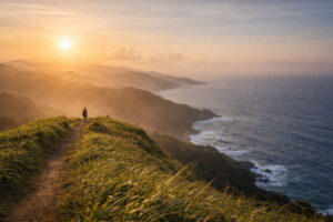
Windswept Hills and Iconic Viewpoints: Story Cards for Green Horizons
This is the heart of Catanduanes: rolling green ridges meeting the Pacific, the island’s signature look. Below are viewpoint “story cards” designed to help you plan without overpromising access. Some spots may be community-managed or may require guides; always ask locally and follow current rules.
Viewpoint Story Card 1: The “Green Ridges to the Pacific” Look
What it feels like: You stand on a grassy rise with wind-bent plants at your feet. In front of you: layered hills falling into deep blue, with white surf drawing bright lines along the coast. It feels spacious enough to reset your brain.
Best time of day: Sunrise for softer light and calmer roads; late afternoon can be beautiful too, but only chase sunset if weather and driving conditions feel safe.
Watch out for: Strong gusts that can throw your balance, especially near edges. Stay back from cliff rims. If the grass is wet, treat every step like it’s on a slick floor.
Viewpoint Story Card 2: Layered Headlands and Distant White Surf
 What it feels like: A cliffside trail (not too dramatic, but still exposed) with headlands stacking into the distance like waves made of land. You hear the ocean before you see it fully.
Best time of day: Early morning when the air is crisp and the light stretches long over the landscape.
Watch out for: Slippery sections after rain and sudden wind bursts. If visibility drops (fog or heavy mist), turn back early. Views are not worth guessing your footing.
Viewpoint Story Card 3: The “Quiet Sunrise” Spot
What it feels like: Fewer voices, more wind and birds. People speak in whispers, not because there’s a rule, but because the place asks for it.
Best time of day: Sunrise—always. This is when Catanduanes feels most like itself.
Watch out for: Noise discipline matters here. Keep music off. If there are residents nearby, treat it like you’re visiting a neighborhood, not a viewpoint stage.
Guide note: access can be community-controlled
Some of the best viewpoints may involve paths that cross private land or community spaces. If you see signs, gates, or locals indicating restricted access, don’t push through. Ask permission, hire a guide when required, and accept that “no” is part of respectful travel. Catanduanes is generous when you don’t act entitled.
Untouched Coves and Beaches: Beauty With Boundaries
Catanduanes beaches often come in two moods: wide and windy, or small and sheltered (when conditions allow). Either way, the Pacific-facing coastline demands caution. Rip currents exist. Waves can change fast. Even strong swimmers should treat open shores with respect.
Wide and windy beaches (walking, wave-watching, breathing space)
Mood: Long walks, strong breeze, big sky. These beaches are perfect for clearing your head, taking photos, and feeling the island’s scale.
Practical note: Swimming can be risky on open Pacific-facing shores. If there are no lifeguards and conditions look rough, choose wading near shore (if safe) or skip the water entirely. Enjoy the beach for what it’s offering that day: wind, space, and movement.
Quieter coves (condition-dependent calm)
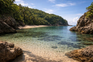 Mood: Smaller, quieter pockets—often with rock formations and clearer shallows when the sea is friendly. These are the places that make you whisper.
Practical note: Tides and swell matter. What looks calm in the morning may change by afternoon. Ask locals about safe swim windows, entry points, and whether conditions are appropriate that day.
Surf culture corners (respectful, low-hype)
Mood: A few boards, a few watchers, the ocean doing what it wants. Surf corners can be beautiful even if you don’t surf—just watching the sea’s energy is part of the Catanduanes experience.
Practical note: If you’re new to surfing, don’t jump in without local guidance. Respect local etiquette, follow safety advice, and remember: the Pacific is not a beginner pool.
Common Safety Risks and How to Plan Around Them
Catanduanes rewards the traveler who plans for safety without making the trip feel fearful. Here are the common risks and the calm responses that keep you capable.
Wind and cliff exposure
Strong gusts can destabilize you near viewpoints. Stay away from edges, avoid risky framing for photos, and keep both feet grounded—especially when the grass is wet.
Rip currents and rough surf
Open beaches can have powerful currents. If you’re unsure, don’t swim. If you do swim, choose sheltered areas with local guidance and never swim alone.
Slippery trails after rain
Wet grass and mud can turn easy walks into risky slips. Use shoes with grip, walk slower than your ego wants, and avoid cliffside trails when visibility is poor.
Road safety and fatigue
Island road days can be longer than they look on a map. Start early, rest midday, and avoid night driving when possible. If you’re on a motorbike, be extra conservative with speed—wind and rain are not forgiving.
Sample Itineraries That Don’t Rush
How many days do you need without rushing? If you want Catanduanes to feel like Catanduanes—space, wind, unhurried views—give it at least 3D2N, and ideally 4D3N if weather buffer matters to you.
A) 3D2N “First Taste” Itinerary
Day 1 (Arrival + gentle town evening): Arrive, settle in, do a short coastal walk if weather is calm. Eat early and sleep early—your sunrise day will feel better.
Day 2 (Sunrise viewpoint + beach day): Start before dawn for a sunrise viewpoint (choose one with safe access and local advice). After breakfast, spend the day on a wide beach for walking and wave-watching, then shift to a calmer cove only if conditions are safe and access is permitted. Rest midday. Chase sunset only if roads are dry and visibility is good.
Day 3 (Falls/heritage half-day + departure): Keep this flexible: a falls visit if trails are safe, or a relaxed town half-day—market, café, slow lunch—before you leave.
B) 4D3N “Green Horizons” Route (slower, with buffer)
Day 1: Arrival + short warm-up viewpoint (something easy, not cliff-exposed) to get your bearings.
Day 2: Sunrise viewpoint day—commit to the early start, then take a long midday rest. Late afternoon beach walk if weather is friendly.
Day 3: Coves and coastal corners day—choose a mix of wide and quiet, based on conditions. If it’s windy or rainy, swap in Plan B activities without guilt.
Day 4: Buffer morning for whatever you missed—another viewpoint if weather finally clears, or an easy café-and-coast morning if you want to leave unhurried.
Pacing notes that keep the trip gentle
Start early for the best light. Rest midday when heat or wind gets tiring. Chase sunset only if roads and weather feel safe. The island’s beauty isn’t a deadline—Catanduanes doesn’t reward rushing.
Respectful Travel Guidelines: Quiet, Permission, and Leaving No Trace
This deserves its own space because it’s part of what keeps Catanduanes beautiful.
Ask permission when trails cross communities or private land
If a trail passes through farmland, a neighborhood, or a clearly managed entrance, ask. Don’t assume public access just because you saw a photo online.
Hire local guides when required (and pay fairly)
Guides aren’t just for navigation—they’re for safety, local rules, and community respect. Pay fairly, tip when you can, and listen when they say a spot isn’t safe that day.
Keep noise low at sunrise viewpoints
People wake up early for the same reason: quiet. Leave speakers behind. Let wind and waves be the soundtrack.
Be mindful with drones and photography
Don’t assume drones are okay, especially near homes or community spaces. Ask first. For photography, be respectful—people are not props, and some spaces are sensitive.
Stay on paths and protect fragile cliff vegetation
Cliff plants and grasses can be fragile, and erosion is real. Don’t create new paths for a better angle. Keep your feet where the trail already exists.
Pack out trash—always
Leave no trace isn’t a slogan here; it’s survival for small, wild places. Bring a small trash bag and carry everything back out.
Catanduanes travel guide FAQs
What makes Catanduanes feel different from other Bicol islands?
Bigger Pacific-facing skies, windswept green ridges, fewer crowds, and a coastline that feels spacious and dramatic. It’s more “wide and wild” than “party beach.”
When is the best time to visit for calmer weather?
Generally, drier months tend to offer calmer seas and easier road days, while stormier months bring higher risk of rough crossings and disrupted plans. If you’re traveling in higher-risk season, add buffer days and lean on Plan B options.
How do you get to Catanduanes, and what’s simplest for first-timers?
Many travelers enter through Bicol/Albay as a gateway and cross by sea, with flying as an option when schedules align. Keep your plan flexible around sea conditions.
What are the best sunrise viewpoints, and what should you expect?
Expect wind, soft early light, and strong “green horizons” scenery—plus safety considerations like slippery grass and gusts. Choose viewpoints with safe access, and ask locally if guides or permission are needed.
Is motorbike travel recommended?
It can be great for confident riders in good weather, but wind, rain, and slick roads are real risks. Safer alternatives include van hire or private car—especially for groups and longer days.
What are the common safety risks?
Strong gusts on cliffs, rip currents on open beaches, slippery trails after rain, and road hazards during bad weather or night driving. Plan conservatively and let weather lead.
What’s a good Plan B when weather cancels beach plans?
Falls (if safe), town cafés and slow lunches, markets, and short viewpoints that don’t require exposed cliff walks. Sometimes the best Plan B is simply a quieter day.
Catanduanes is the kind of place that teaches you a softer way to travel. You listen to the wind before you chase the view. You accept that the sea can say “not today.” You learn to love space—green hills rolling forward, waves throwing white lines against rock, and the calm pride of an island that doesn’t beg for attention. Follow the weather, follow local guidance, keep your steps gentle, and this Catanduanes travel guide will feel less like a plan—and more like a journey you can trust.
For more Luzon trip ideas you can stitch around Bicol and beyond, explore Luzon destination guides and build a route that leaves room for wind, rest, and wide horizons.

")


")
: Best Areas For First-Timers")