

There’s a moment on the road to Kalinga when the land suddenly drops away on one side and the Chico River appears below—wide, brown-green, and moving with its own steady power. The air turns cooler, your jeepney hugs the curve a little tighter, and you realize this isn’t just any provincial highway. This is the beginning of the Kalinga river roads, where the Chico and the asphalt travel side by side like old friends.
On one side: river bends, rapids, smooth pools, stones the size of houses. On the other: rice terraces climbing the slopes, clusters of houses, hanging bridges swaying in the breeze. Somewhere in between are the stories—about weaving, tattoos, rice harvests, and the long fight to protect this valley from a dam that would have drowned entire communities.
This guide follows Kalinga river roads from Tabuk toward Pasil, Lubuagan, and Tinglayan, with side trips into villages. We’ll talk about how to get here by bus or van, what the road actually feels like, where you can experience Chico River rafting, how to visit indigenous communities and weaving centers respectfully, and what a realistic 3–4 day Chico River Kalinga travel guide itinerary looks like.
Introduction to Kalinga River Roads
When we say Kalinga river roads, we’re talking about the routes that trace the Chico River as it carves through the mountains: the approach from Tabuk, the curves toward Pasil and Lubuagan, and the climb onward to Tinglayan and its villages. These aren’t expressways—you’ll travel on narrow mountain roads, with guard rails in some sections and open drops in others, and the river always somewhere below, shining or roaring depending on the season.
For Kalinga communities, the river and these roads are lifelines. Trucks bring goods in; rice and coffee go out. Students commute along them, elders ride to town to visit family or attend meetings, and travelers like you step into this flow hoping to learn without disrupting it. To really understand Kalinga river roads, you have to see them not just as scenic drives, but as part of a living landscape and history.
Meeting the Chico River: River of Life in Kalinga
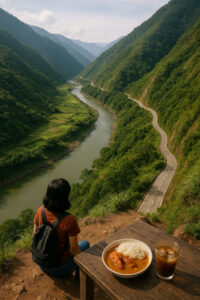 The Chico River flows through several Cordillera provinces, but in Kalinga it feels especially close—a constant presence beneath the cliffs and terraces. Locals call it a river of life because it irrigates rice fields, sustains fish and other food sources, and serves as a route for transport and trade. Along Kalinga river roads, you’ll see irrigation canals branching off, farmers guiding carabaos near its banks, and children playing at shallow sections when the current is gentle.
The river also carries heavy history. In the 1970s and 80s, proposed Chico River Dam projects threatened to flood villages and ancestral land. Kalinga and Bontoc communities resisted, defending their territory and way of life. Many travelers first read about this in short summaries, like the entry on the Chico River, then arrive and realize: these aren’t just “case studies.” They’re ongoing stories held in people’s memories, songs, and rituals.
When you travel the Kalinga river roads today, you pass through places where those meetings, protests, and negotiations happened. You may hear snatches of stories over coffee: about relatives who joined mass actions, about the fear of losing rice fields, about the relief when the dam was stopped. Listening to these stories is part of the journey, and it’s important to come with humility and respect for the emotional weight they carry.
Getting to the River Roads (Access and Routes)
Reaching Kalinga river roads takes time, and that’s part of why the journey feels so different from quick beach getaways. Expect long bus hours, terminal waiting benches, and those first glimpses of mountains that tell you: okay, city life is really behind me now.
From Tuguegarao or Manila to Tabuk
Tabuk City is the most common lowland entry point. From Manila, you typically take an overnight bus heading toward Tuguegarao or direct to Tabuk if schedules allow. Travel times are long—often 10 hours or more depending on traffic and stops. From Tuguegarao, Tabuk is just a few hours away by bus or van, making it a practical jump-off if you’re already exploring Cagayan Valley.
As you approach Tabuk, the landscape shifts from lowland fields to rolling hills, then to the edges of the Cordillera. The air is still warm, but the horizon grows more jagged. Once in Tabuk, you’ll find vans, jeepneys, and sometimes buses heading toward the interior—Pasil, Lubuagan, and Tinglayan—depending on the time of day and current road conditions.
From Baguio or Bontoc into Kalinga
Some travelers come from the west—Baguio, Bontoc, or other Cordillera routes—as part of a bigger northern Luzon loop. From Baguio, you can ride to Bontoc, then transfer to Kalinga-bound jeepneys or vans. The road between Bontoc and Kalinga crosses high passes and often gives dramatic glimpses of river valleys far below.
If you’re planning a wider highlands circuit that combines Kalinga with other mountain destinations, you can look at the Cordillera Region guides and even our Sagada and Banaue mountain journey as reference for how to string these places together. Kalinga can be a powerful middle chapter in a longer Cordillera story.
If you want to add an outdoor “sleep in the mountains” chapter between towns, use Cordillera camping Philippines as a practical guide to cool-air camps, what to pack, and how to keep your nights comfortable and respectful in the highlands.
Local Rides Between Tabuk, Pasil, Lubuagan, and Tinglayan
Within Kalinga, expect jeepneys, vans, and sometimes small buses. Schedules can be irregular, more “when full” than hourly, so factor in waiting time. Locals are your best source of updated info—drivers, sari-sari store owners, and municipal tourism offices.
The actual feel of Kalinga river roads? Curves that cling to mountainsides, occasional rough patches or roadworks, and sections where you look straight down to the river far below. Fog can roll in suddenly, softening the landscape into grayscale; then a few minutes later, the sun slices through and the terraces glow bright green. Signal is patchy. This is a place where you download music or podcasts in advance and accept that “offline” will be your default.
Segments of the River Roads: Tabuk to Tinglayan
As you travel deeper into Kalinga, the river and road feel like paired chapters of one long story. Here’s how the main segments unfold and what to watch for along the way.
Tabuk and the Rafting Jump-off
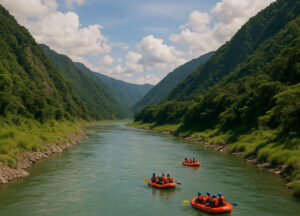 Tabuk is both a provincial center and a gateway to adventure. For many travelers, this is where they arrange Chico River rafting, especially during the months when water levels are ideal. Trips range from beginner-friendly runs to more technical rapids, so always be honest with outfitters about your experience and comfort level. They’ll advise whether a “chill but exciting” route or a more intense stretch is right for you.
White-water Chico River rafting is best done with accredited guides and proper gear—helmets, life vests, briefing on commands. Ask about safety protocols, rescue procedures, and how weather affects cancellations. Season matters: rainy months can bring powerful flows and higher risks, while drier months may mean lower water but clearer views of rocks and riverbanks. If you’re more into scenery than adrenaline, say so. The point is to enjoy the river, not to prove anything.
Pasil and the Chico River Rafting Runs
As you move toward Pasil, the road begins to mirror the Chico more closely. You’ll see sections where the river tightens into rapids, stones piled along its edges like guardians. This is where some Chico River rafting put-ins and take-outs are located, depending on your operator’s chosen route and water conditions.
The valleys here feel narrower, sound bouncing off both sides—river rush, jeepney engines, sometimes children’s laughter from houses perched above. This is also where you start to sense how central the river is to community life: clothes lines overlooking the water, footpaths leading down to washing spots, and small clusters of houses where people move with the rhythm of river days and rice seasons.
Lubuagan and Mabilong Weaver’s Village
Lubuagan is a historic town, once a political center in the Cordillera, and today a key stop along Kalinga river roads. From here, you can visit Mabilong, known for its weaving. In Mabilong Weaver’s Village, you’ll see backstrap looms set up on porches and under the shade of houses, threads stretched tight and colors flashing between the hands of weavers.
The scenery between Pasil and Lubuagan is gorgeous—river bends, terraced hills, occasional viewpoints where you can safely pause to absorb the view. Ask your driver or guide where it’s okay to stop; some spots are too narrow or dangerous to linger. When you reach weaving communities, go slowly. Greet people, observe first, and ask before taking photos, especially of individuals at work.
Tinglayan, Luplupa, and Buscalan Side Trip
Further along Kalinga river roads lies Tinglayan, a municipality with villages scattered along the river and up the slopes. Across a hanging bridge from the roadside is Luplupa, one of the more accessible riverside villages, where homestays give you views of the Chico from wooden balconies.
From Tinglayan, many travelers make the trek up to Buscalan, a village made famous by traditional tattooing—once associated with warrior culture, now shared in a new context with visitors. The climb takes you away from the river for a while, but you’ll often still hear its distant murmur from higher up, a reminder of how everything in this landscape is connected.
Indigenous Communities and Cultural Encounters
The heart of any Kalinga river roads journey is time spent in indigenous communities—listening more than talking, learning more than posting. Kalinga people have deep relationships with the land and river, and it’s a privilege to be invited into their spaces, even briefly.
Buscalan, Tattoos, and Visiting with Respect
Buscalan is known worldwide because of Apo Whang-od and Kalinga tattoo traditions. Today, she and other tattoo artists in the village welcome visitors who come for hand-tapped designs. But this is still a home, not a theme park. Expect basic paths (often muddy in the rain), simple lodging, and set systems for queuing and payment that are agreed upon by the community.
Go with a registered guide, follow village protocols, and be patient with schedules—if there’s a community event, weather issue, or elder need, plans can change. When you receive a tattoo, remember it’s not just an accessory; it carries part of a living tradition that survived colonization and conflict. Carry it with respect, and support other tattoo practitioners in the village, not just the most famous name.
Tinglayan Villages and Evening Life by the River
Staying in Tinglayan or nearby villages gives you a different kind of encounter—more everyday, less spotlight. You might sit on a porch at dusk as children play on the hanging bridge, roosters settle, and elders chat in Kalinga languages you don’t understand, with occasional Tagalog or Ilocano words floating through. The generator hum may stop earlier than you’re used to; the night becomes very dark, and the sound of the Chico fills the silence.
Here, cultural stories show up not just in formal briefings, but in casual conversation: someone pointing out a field that belonged to their grandparents; a song hummed while cooking; a story about a time the river flooded, or about the protests against the Chico River Dam. These are pieces of memory, not tourist performances. The most respectful thing you can do is listen carefully, ask permission before sharing, and remember that not all stories are yours to repeat online.
Kalinga Weaving and the Stories in the Cloth
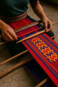 Weaving is one of the most visible forms of Kalinga artistry along these roads. In places like Mabilong and Lubuagan, you’ll see bold patterns and strong colors: reds, blacks, whites, sometimes blues and greens, arranged in stripes and motifs passed down through generations.
Mabilong’s Backstrap Looms
In Mabilong Weaver’s Village, backstrap looms are often anchored to posts or beams, with the weaver leaning back to create tension. Each movement—passing the shuttle, beating the weft—builds up a fabric of memory. Some designs stand for specific communities or status; others mark rituals, protection, or everyday use.
If you’re curious about meanings, ask gently: “Ano po ang kwento ng pattern na ito?” or “May ibig-sabihin po ba itong design?” Some weavers may be happy to explain; others might simply smile and continue working. Either is okay. The important thing is to recognize that you’re not just buying a pretty cloth—you’re touching something rooted in land, water, and community.
Buying Textiles as Relationship, Not Bargain
When you buy a woven belt, blanket, or wrap along Kalinga river roads, you’re contributing to a livelihood that takes time and skill. It’s okay to ask the price and clarify what’s handwoven versus factory-made. Light negotiation may happen, but avoid pushing for rock-bottom. Think of it as a relationship: you’re thanking the weaver for their work and helping keep the tradition alive in a fair way.
If you take photos of weavers or their work, ask permission first—especially if you plan to post online. A simple, “Pwede po bang mag-picture?” goes a long way. Some communities may have specific rules about photography; your guide or homestay host can help you understand them.
Everyday Food and Roadside Life
Traveling the Kalinga river roads isn’t just about big activities like rafting or trekking. It’s also about simple meals, steaming coffee, and the rhythm of life along the road.
Rice, Coffee, and Simple Mountain Meals
 Breakfast in many homestays is straightforward: rice, eggs, maybe longganisa or tinapa, and hot coffee that tastes especially good in the cool mountain air. Lunch might be tinola with native chicken, or vegetables from the terrace just below the house. You’re not here for fancy plating; you’re here for warmth and sustenance.
Along the road, you’ll encounter small eateries where drivers stop to eat. Don’t be shy about joining them. Point to the ulam trays, ask what’s spicy, and listen to the mix of languages swirling around. These stops are great places to gather real-time information about road conditions and weather.
Evening Moments by the River
Nights along Kalinga river roads can feel extra quiet if you’re used to city noise. There might be a bit of karaoke somewhere, but often it’s just conversation, the chirp of insects, and the steady sound of the Chico. Bring a light jacket, a notebook, or a book. This is a good time to reflect, write, or simply sit with your thoughts while the river moves below.
Sample Kalinga River Roads Itineraries
How many days do you need? Ideally 3–4 days for a core Kalinga river roads trip, more if you’re combining it with other Luzon mountains or lowland destinations from our wider Luzon travel guides. Here’s a sample to get you started.
4-Day Chico River Valley Journey
Day 1: Arrival in Tabuk – Travel from Manila, Tuguegarao, or Bontoc to Tabuk. Check into a simple inn or guesthouse, shake off the bus hours, and arrange next-day transport. If there’s time before sunset, walk around town, pick up supplies, and get an early briefing on current rafting conditions or village access from local contacts or the tourism office.
Day 2: Rafting and Transfer Deeper into Kalinga – Begin your day with a Chico River rafting run suited to your comfort level. After lunch, travel onward toward Pasil or Lubuagan, watching as the Kalinga river roads narrow and scenery intensifies. Stay at a homestay or guesthouse en route; spend the evening listening to stories from your host and adjusting to slower mountain time.
Day 3: Weaving and Tinglayan – Visit Mabilong Weaver’s Village or another weaving community around Lubuagan. Buy textiles directly from weavers if your budget allows, then continue toward Tinglayan. Check into a homestay—maybe in Luplupa, across a hanging bridge from the main road, so you sleep with the Chico whispering below. If you have energy, take a short village walk before dusk.
Day 4: Buscalan or Village Immersion, Then Exit – If you’ve arranged a Buscalan visit, this may be the day you do the hike, get tattooed by local practitioners, and experience village life above the river. Otherwise, spend more time in Tinglayan’s closer villages, sharing meals and learning about local history. In the afternoon, start your journey back toward Tabuk and onward to your next destination, whether that’s home or another Cordillera stop like Sagada or Banaue.
Shorter 2–3 Day Version
If your leave is tight, you can still get a taste of Kalinga river roads:
Day 1: Travel to Tabuk, then push onward to a mid-point homestay if your arrival time and energy allow.
Day 2: Focus on one highlight: a rafting day, a focused weaving visit, or an overnight in Tinglayan or nearby riverside village.
Day 3: Begin your return trip, possibly with a final morning walk along the road or hanging bridge for one last look at the Chico River below.
This compressed version doesn’t cover everything, but it can be a powerful first encounter with Kalinga river roads and a stepping stone toward a longer visit next time.
Practicalities, Safety, and Respect
Kalinga river roads are beautiful, but they’re also remote, with real risks and responsibilities. A grounded trip means balancing curiosity with caution.
Weather and Best Time to Go
Dry months generally offer more stable road conditions and clearer views. Rainy season can bring landslides, muddy paths, and more dangerous river currents. Rafting season typically aligns with times when the water is high enough for good runs but not so wild that it becomes unsafe; confirm this with local operators before you finalize dates.
Fog is common at higher elevations, especially in the mornings and late afternoons. It can make roads more challenging to drive, but also creates beautiful, shifting light across the terraces and valley walls.
Safety, Road Conditions, and Advisories
Mountain roads demand respect: sit properly inside vehicles, avoid leaning over open sides, and trust local drivers who know the curves by heart. If you’re driving your own car, make sure it’s in excellent condition, with good brakes and tires, and be prepared for rough patches or one-lane sections where you must yield.
Before your trip, it’s wise to check for updated information on advisories, road works, or community notices from official channels like the Kalinga tourism page or municipal tourism offices. Weather can change quickly in the Cordillera; build flexibility into your plans in case you need to stay an extra night somewhere for safety.
Cultural Etiquette and Budget Notes
In Kalinga villages, you’re entering spaces with their own rules and protocols. Dress modestly—long pants or skirts, covered shoulders, especially in more traditional communities. Always ask before taking photos of people, private homes, or ceremonies. Keep noise low at night; what feels like early evening to a city person might already be resting time in the village.
Alcohol should be consumed carefully, if at all. Some communities may have specific customs around drinking; follow your host’s lead and never pressure anyone to join. Gifts can be thoughtful but simple—coffee, biscuits, or small school supplies—offered respectfully, not as payment.
Budget-wise, expect homestay rates and simple meals to remain within a backpacker-friendly range, though prices vary by location and season. Guides and porters deserve fair pay; ask your host or tourism office about standard rates so you’re not unknowingly underpaying. Rafting, transport charters, and long van rides will be your bigger expenses, so allocate generously there.
Signal is patchy to non-existent in many segments of the Kalinga river roads, which can feel unnerving if you’re used to constant connectivity. For solo travelers, this adds an extra layer of mental prep; our solo travel in the Philippines guide can help you think through safety, communication plans, and how to handle the emotional weight of being offline in unfamiliar territory.
When you’re ready to build out a more detailed route or combine Kalinga with other northern stops, you can dive into our broader Philippines travel guides and the Luzon destinations overview to sketch loops that connect the highlands, lowlands, and coast in a way that matches your time and energy.
In the end, traveling the Kalinga river roads is less about ticking off attractions and more about following a living river through mountains and memories. It’s about feeling your jeepney climb another curve, looking down at the Chico flowing below, and realizing that this road has carried generations of Kalinga people long before you arrived and will keep carrying their stories long after you leave. If you can move through it with humility, patience, and openness, the roads and river will quietly change how you see the rest of your travels.
")


")
: Best Areas For First-Timers")
